Argentina possesses numerous National Parks, created to preserve landscapes, geological, paleontological patrimonies, and native flora and fauna, offering an impressive variety of outdoor activities and environment, from the subtropical rain-forest in the North part of the country to the glacial zones of Tierra del Fuego in the South, also visitors can know about the fauna and flora of the different regions which conform Argentina.
Admire fossils and geological formations and enjoy activities like fishing, trekking, rafting, mountain biking; now, parks have camping areas and refuges (refugios) for more comfort to the tourist. Some of these parks are on UNESCO World Heritage List for natural values.
Here we offer the details of some of the most important parks:
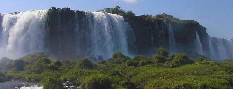
Iguazú Natural Park
This park was created in 1934, declared Natural Patrimony of the Humanity by the UNESCO, this park has an extension of 67.000 hectares, is one of the last exponents of the subtropical forest in the continent, and contains one of the world’s scenic wonders: The Iguazú Falls, with its 275 falls, some of them with more than 70 meters of height forming a semicircle of approximately 2700 meters, we can mention its main falls: the Devil’s Gorge (Garganta del Diablo), Mitre, Bozetti, Two Sisters (Dos Hermanas), Belgrano, Three Musketeers (Tres Mosqueteros), Rivadavia, San Martín, Adán and Eva.
Its existence is aimed at the preservation of one of the richest natural environment, with more than 400 species of birds, around 2,000 vegetable species, and a vast world of insects, the park is home also of endangered species like jaguars, ocelots, tapirs, tiricas, giant anteaters, pavas de monte, jungle eagles, howler monkeys, yacarés overos, coatí, birds like the vencejo de cascada and large toucans, and a diversity of butterflies.
This park possesses complete installations for the tourist, who can arrive through route 12 from the south and Route 101 from the east. The closest town is Puerto Iguazú (17km. west of the falls).
Nahuel Huapi Natural Park
Nahuel Huapi Natural Park, created in 1934, is one of the first in the world and the first South American park, the name comes from the Mapuche language, where Nahuel means tiger and Huapi means island, is located in the southwest of Neuquen province and northwest of Rio Negro, between the Patagonia plateau and the Andes. It has an area of more 766.000 hectares and comprises medium height mountains, glaciers, rivers, lakes, forests, and valleys.
Its bigger and most important attraction is Nahuel Huapi lake, a 100 km long lake, situated in the center of the park, it maximum depth is 464 meters, the lake contains several islands, like the Victoria Island, home of exotic animals, like the pudú and the huemul and rare species of trees, and Huemul Island, which was home of the Huemul Project, a secret project on nuclear fusion developed by Argentina in 1949-1952.
Is an excellent region for outdoor sports like trekking, among its mountainous relief typical of the southern Andes. The more important peaks of the park are the Tronador (3554 m.a.s.l.), Catedral (2388 m.a.s.l.), Bayo (1750 m.a.s.l.). Nahuel Huapi, has also a large number of lakes of different sizes with a lot of fish, such as the vast Nahuel Huapi, the Traful, the Correntoso, the Falkner, the Mascardi, the Gutiérrez, the Moreno, the Villariño and others lakes, The area is known as the Argentine Lake District.
The park has rich wildlife; by example; the park contains huemuls, guanacos, pumas, pudús (short deer), huillín (river wolf), red fox, skunk, short weasel, etc.; birds as the cormorant, cooking gulls, black neck herons, woodpeckers, witch heron, great bustard, parakeets, and condors; the ichthyic fauna conformed by autochthonous species such as the perch, the puye, the Patagonian herring smelt, etc. and exotic ones such as the Rainbow trouts.
The flora seen in the park include alerces (a Patagonian cypress), arrayanes (Myrtle), ferns, Coihues, ñires, amancays and many others.
Laguna Blanca National Park
Laguna Blanca was created in 1940, it is situated in the northwest of Neuquén province, at 30km from the town of Zapala, it has a surface of 1,700 hectares, the main object of this park protects the area where the black-necked swan (Cygnus melancoryphus) nests, the lake was constituted when lava flows dammed two little streams, it has 10 meter depth, receives water from the Llano Blanco brook and the Pichi-Ñireco brook and is located in the Patagonian steppe, surrounded by hills and gorges.
It features important aquatic bird fauna such as: black neck swan, gallaretas, ducks, chorlos, flamingos, “macáes plateados”, also, exists animals as Patagonic aquatic frogs, pumas, foxes, choiques, piches and condors. The area has been declared a wetland of international importance by the RAMSAR Convention, for its importance to waterbirds.
Another attraction is the Salamanca cave, where prehistoric paints and artifacts can be seen.
Lanín National Park
The Lanín National Park was created in 1937, its name comes from its centerpiece the Lanín volcano (3,766 meter), it is located in the southwest part of the province of Neuquén, its area comprises 379,000 hectares, where 194,600 hectares belong to the park and the remaining 184,400 belongs to three sectors of reservation. This park was created to preserve a representative sector of the northern Patagonian Andes woods and forests, such as the araucaria, pellin oak, evergreen beech, rauli, pehuen, plus lenga, nire, coihue. This is one of the best tourist regions in the country.
Lanín hosts numerous rivers and lakes such as the Escondido, Hermoso, Huechulaufquen, Lácar, Lolog, Machónico, Meliquina, Paimún where sport fishing cab be practiced, the ichthyic fauna is conformed by species such as brown trout, fontinalis, patagonic herring, puyén, rainbow trout and others, the animal life comprises huemuls, pudús, huillíns, pumas, red and grey foxes, skunks, ferrets, wild boars, birds such as gulls, herons, rayaditos, woodpeckers, thrushes, etc.
The city of San Martin de los Andes is the hub to visit the park, this city can be reached along National Route 234, also, there are international road crossings from Chile, and daily internal flights at the Chapelco Airport (24km from San Martin de los Andes).
Alerces National Park
The Alerces National Park was created in 1937, is located in the west of Esquel, province of Chubut, covers an area of 263,000 hectares and its objective is to protect the “Alerce” (Fitzroya cupressoides), a giant conifer called the redwoods of South America, individual specimens of this beautiful and long live tree grows very slowly but can measure over 150 feet in height and 12 feet in diameter, it has suffered overexploitation. This park tries to protect some of the largest remaining Alerce woods.
The most visited forest in the park is at Puerto Sagrario, at the northern end of Lago Menendez, also Arrayán forests can be seen along the Arrayanes river. The park has a flora similar to Nahuel Huapi and Lanín National Parks, adding Coihues and Lenga specimens to the Alerce trees. This park features mountainous reliefs with beautiful snow-capped peaks, this is a perfect scenery for walking tours and trekking adventures.
There is a large number of rivers and lakes rich in Salmons, the main includes the Futalaufquen, Krüger, Menéndez, Rivadavia and Verde lakes and the Frey river, offering a excellent opportunity to practise fishing, The Limonao port in Futalaufquen lake and the Chucao port in Menéndez lake, are the departure point for boat trips on the lakes.
For more information, tourists will go to the Visitor Centre, the National Park Intendence or ask to the Forest keeper headquarters.
Los Glaciares National Park
Los Glaciares National Park, created in 1937, is situated in the southwest of Santa Cruz province, in Argentine Patagonia, it occupies 600.000 hectares. Was declared a UNESCO World Heritage Site in 1981, its objective is to preserve the astonishing biosphere of exceptional natural beauty, formed by large highland lakes, reflecting mountains peaks, and the imposing glaciers.
Los Glaciares National Park offers the wonderful chance to see some of the most impressive forces of nature, the southern section has the Perito Moreno Glacier, the Upsala Glacier, and Spegazzini Glacier, which flow into Argentino Lake, the Perito Moreno Glacier is the most spectacular and the easiest to reach, thousands of tourists come to attend its spectacular scenery, the Spegazzini and Upsala are inaccessible by land, but, can be reached by boats travel. The north part has a large number of mountains and lakes, including part of the Viedma Lake, the Viedma Glacier, and the Cerro Fitz Roy, which exceeds 11000 feet, becoming in a dangerous and extremely challenging climbing area very popular for fans of trekking and climbing.
The most important lakes are: the Lake Argentino, the biggest in Argentina, 1,466 square meters, and the Lake Viedma, with 1.100 square meters, those lakes, features black neck swans, flamingos, flying steamer ducks, south-american coots and upland geese in its aquatic bird fauna, both lakes feed the Santa Cruz River, that flows to Puerto Santa Cruz on the Atlantic.
The park combines the majesty of the environment with a particular fauna, consistent in Ñandus, Hares, Armadillos, Huemuls, Hullins, Pudús, Andean Condors, Gray-Eagle-Buzzards, Magellanic Woodpeckers, Chilean Flamingos, Foxes, many of them in danger of extinction and a vegetation formed by Ñires (nothofagus antartica), Lengas (nothofagus pumilio) and Guindos ( nothofagus betuloides) forests, some isolated Canelos (drimys winteri) and the typical flower of the Andean Patagonian Forest, the Notro (embothrium coccineum).
Talampaya National Park
The Talampaya National Park was created in 1975 as a provincial reserve and in 1997, declared a National Park, has a surface of 215,000 hectares, at an altitude of 1,500 meters above sea level, it is located in mid-west of La Rioja Province, was created to preserve important paleontological and archaeological sites found in the area. The Talampaya Natural Park and his neighbor Ischigualasto (located in San Juan) were declared a UNESCO World Heritage Site in 2000.
This park is the result of erosion in a desert climate, contain fossils of dinosaurs, ancestors of mammals and plants, exists walls up to 143 meters high and deep canyons of around 180 meters of height, this canyons were eroded forming peculiar formations such as the Monje de Piedra (Stone Monk), the Hombre Sabio (Wise Man), the Torre (Tower). Another formation in the Ciudad Perdida (Lost City), a depression of approximately 2 km, with sandy formations and estrange rocky figures. Over walls and big rock, tourists can see petroglyphs and ceramics representing human, animal or geometrical figures belonging to the inhabitants that occupied the land thousand of years ago.
Tampalaya has landscapes of great beauty, the fauna of this region include guanacos, maras (a Patagonic hare), foxes, ferrets, sierra squirrels, chuñas de patas rojas, charatas, corzuelas, pecaríes, tapires, river foxes, mayuatos, pumas, condors and others; the flora of the Mountain biome is formed by plants such as horco quebracho, cochucho, atamisque, cardones, cedro, tarco, tipa, nogal, palo barroso, alpamato, mato, chal- chal, güili, claveles del aire, orchids and others.
Baritú National Park
Baritú National Park, was created in 1974, is located in the Santa Victoria Department, in the north of the province of Salta, this park occupies an area of 72,439 hectares. It is the only tropical park in the country and protects an area belonging to the Yungas ecosystem, a sub-tropical mountain jungle with wet and hot climate, summer rainfalls, irregular reliefs, peaks measure 300 to 400 meters in height, cloud-forests with full development (for example, the Cedro Salteño, reach huge sizes in this region) and with a large number of rivers, the most important of them is the Lipeo River. The fauna of the park, include several species in extinction, such as the yaguareté and the onza.
Among the flora species we can find ferns, maromas, cedars, mirtáceas, pepper trees, pines, american timber trees, walnut tress, lindens, oaks, matos, güili, tipas, pacaráes, cebiles, tarcos, cochuchos and others.
The fauna is conformed by the following species: tigers, pumas, wildcats ounces, little bear washer, squirrels, monkeys, coaties and others. Fish such as American shads, the dorado, the bogue and others, in Baritú lives the biggest eagle in the world, the Aguila Arpía.
Tierra del Fuego National Park
The Tierra del Fuego National Park, was set up in 1960, covers a 63,000 hectares surface, is situated on the Argentine part of the island of Tierra del Fuego, within Tierra del Fuego Province, close to the city of Ushuaia. This park has a landscape with a succession of high and irregular mountains, glacier valleys, rivers, lakes, waterfalls, forests. Several areas of the park are restricted to protect the environment. The climate of the region goes from warm to cold, with snow and winter rains.
In the region, there are several animal species such as: red foxes, guanacos, condors. Birds such as: ostreros del sur, cauquenes blancos, albatros de ceja negra, vapor ducks, zambullidor petrels, hualas, cauquen común, grey head cauquen, black Patagonian woodpeckers and also some sea mammals. Puyen and peladilla fishes can be found in rivers and lakes and in the sea, robalos, pollacks and sardines can be seen.
Exists animals such as rabbits, beavers, “almizclera” rats, and others which were introduced to the area by the man, and have caused a serious damage to the environment, for example, beavers cut trees to construct their dikes, originating floods in sectors of the forest and the death of many trees.
In the lower parts of the park, the vegetation is conformed by species such as ñire, lenga, coihue, notro, leñador, sour cherry tree, Magallanes orchids, ferns, mushrooms.