Barbados Beaches by Region
The beaches on Barbados can be divided into their coastal locations: the north, south, east, and west coasts. In some areas of the island, especially in the northern regions, coral and sandstone cliffs come straight up out of the ocean and can reach several hundred feet in height. In the south and west, cliffs of 50 to 100 feet rise and fall along the coast, separated by small sandy beaches and bays. Coral formations along the coastlines of large and small beaches often interrupt the flowing sands. The soft coral rocks that have been weathered by the ocean surf form what looks like abstract sculptures posing along the beach.
Bridgetown Barbados Beaches
With a gorgeous location beside the white-sand beaches of Carlisle Bay, busy Bridgetown is the capital and only city of Barbados.
One of the oldest cities in the Caribbean, the architecture of Bridgetown today is largely a blend of attractive, balconied colonial buildings, warehouses and brash modern office blocks.
The center of activity is the Careenage, parking place for numerous sleek yachts overlooked by the Barbadian parliament.
A number of the island’s main religious buildings are within five minutes’ walk of here, including St Michael’s Cathedral and the synagogue , both erected on the sites of their mid-seventeenth-century originals.
Bridgetown is an extremely safe city, even at night, though you may want to avoid the seedy area southeast of the Fairchild Street bus station, particularly around Nelson Street and Jordan’s Lane where the red-light district is located.
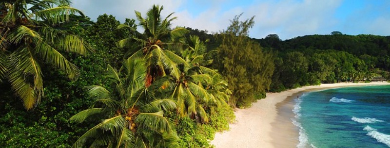
East & North Coast Beaches Barbados
The east and north coasts of Barbados face the Atlantic Ocean, where huge waves crash along the shore and coral reefs. Because the ocean currents and waves are so strong on the east coast of Barbados, this area is not recommended for swimming. However, experienced swimmers can try swimming in protected bay areas and small pools formed by splashing waves along the shore that create a natural swimming pool. An unknowing swimmer can easily be carried away by the strong currents and fierce waves that beat against the coral reefs. This is truly an example of the amazing power of the ocean. Instead of watersports and swimming, vacationers may enjoy a relaxing stroll on the east coast beaches, or tanning on the sandy shores.
The waters on the northern coast of Barbados are also choppy, and it is dangerous to swim in open waters. But the scenery on this side of the island is something to behold. The panoramic views and amazing landscape make the north coast the perfect spot for a beach picnic or some afternoon sightseeing. When visiting this part of the island check out private bays like River Bay and Cove Bay, rugged cliffs overlooking the ocean, and beach caves perfect for exploring.
For many, the rugged, little-explored east coast is the most beautiful part of Barbados.
Almost all year round, the Atlantic waves crash in against this wild coastline, making for superb surfing but difficult and sometimes dangerous swimming.
It’s certainly worth making the effort to explore since this is a very different side of the island from the heavily touristed south and west; if possible, try to spend a night or two up here.
Although the coastal scenery is the main attraction, there are a few specific places that merit a visit, most notably the delightful Andromeda Botanical Gardens.
Specific sightseeing apart, this is a lovely area to drive through, particularly under the steep-sided Hackleton’s Cliff that runs parallel to the coast, where the road weaves through lush tropical forest, offering stunning views over the ocean.
You can also walk along the beaches at Bath and Martin’s Bay, watching the surf ride in.
South Coast Barbados
Barbados’ south coast has something that even the most discerning of travelers can enjoy. The waters off the southern coastline of Barbados are a mixture of the Caribbean Sea and the Atlantic Ocean, and are calm enough for swimming, snorkeling, and other aquatic activities. The beaches on the southern coast are more lively than those on the west coast, but more laid back than the east or north coasts.
For more exciting beach front parties head for the The Boatyard, where you can find all kinds excitement, including an Internet cafe, bars, restaurants, and other great entertainment spots. Also, beach bums can rent a variety of equipment such as beach chairs, umbrellas, kayaks, volleyball equipment, and ocean trampolines. Pedal boats, glass bottom boats, snorkeling tour, and much more are available at The Boatyard on the south coast of Barbados. Another popular beach on the south coast is Dover Beach, which has mild waves and a number of nearby facilities.
The southwestern parish known as Christ Church, the birthplace of tourism in Barbados, is dominated by the trappings of the holiday industry.
The main highway here hugs the coast, linking a string of small resorts; each consists of a fringe of white-sand beach backed by a cluster of hotels, restaurants and tourist facilities.
On the whole, the area is not as beautiful as the west coast, nor as lorded over by the staggering palaces of the mega-rich, but the beaches are just as fine, there are plenty of good eateries, and prices are much more reasonable.
As you head east from Bridgetown towards the airport, several of the coastal towns bear the names of British seaside resorts. Each has its speciality, however: you’ll find the best beaches at Rockley and Worthing, the liveliest restaurants and nightlife at St Lawrence Gap, and a bustling local scene at Oistins, while the quieter beaches at Silver Sands attract windsurfers and those who want to spend their holiday strolling on relatively deserted stretches of sand.
On the other side of the airport, in the southeast of the island, you enter the far less developed parish of St Philip. There’s just a handful of hotels here, but the scenery is spectacular, with the Atlantic waves lashing the rocky coast.
West Coast Barbados
The Platinum Coast, as the west coast of Barbados is often referred to, is well known for the sparkling warm waters that gently lap onto beaches of golden sand. For the most part, the waters of the west coast are calm and the beaches clean, so you can take a refreshing dip in the salty sea or soak up some sun on any of this region’s magnificently golden beaches. Almost all of the beaches on the west coast feature smooth sapphire waters that are ideal for swimming, and clean coral sands on which to relax and soak up the radiant island sunshine.
Its sandy beaches and warm blue waters have made it the island’s prime resort area. As a result, the coastline has been heavily built up; it holds the island’s top golf courses and priciest hotels, and its sought-after private homes change hands at formidable prices.
You don’t, however, need to win the lottery to visit. There’s a smattering of reasonably priced places to stay and, as everywhere on Barbados, all of the beaches are public.
Admittedly, it’s a bit of a tramp to reach a few of them, but there are many beaches that are well worth a visit, particularly those at Prospect, Sandy Lane and Mullins Bay. If you’re into some serious exercise it’s even possible to walk most of the way along the coast at low tide.
Along with postcard perfect beaches, the west coast also features spectacular underwater scenery. Folkstone Marine Park is an underwater park where vacationers view exhibits beneath the ocean surface, go diving, and take part in other ocean-related activities. The park also has shops, museums, and a place to rent snorkeling gear.
Barbados Beaches Map
Each of Barbados’ coasts boasts different kinds of beaches. Whether you’re in the mood for some exciting watersports action, or feel like a more relaxed environment on a secluded beach, Barbados has it all.
| Name | Location | Coast |
|---|---|---|
| Accra Beach | 2.8 mi. Southeast of Central Bridgetown | South |
| Barclays Park Beach | 2.1 mi. Northwest of Central Bathsheba | North East |
| Bath Beach | 3.8 mi. East-Southeast of Central Bathsheba | East |
| Bathsheba Beach | Bathsheba, Central Barbados | North East |
| Batts Rock Beach | 2.7 mi. North-Northwest of Central Bridgetown | South West |
| Bottom Bay | 0.6 mi. East of Central Harrismith | East |
| Brandons Beach | 1.4 mi. North-Northwest of Downtown Bridgetown | South West |
| Brighton Beach | 2.0 mi. North-Northwest of Downtown Bridgetown | South West |
| Brownes Beach | 1.0 mi. Southeast of Downtown Bridgetown | South |
| Carlisle Bay | 0.5 mi. Southeast of Downtown Bridgetown | South West |
| Cattlewash Beach | St. Joseph Parish, Central Barbados | North East |
| Cockspur Beach | 1.9 mi. North-Northwest of Downtown Bridgetown | South West |
| Coconut Court Beach | 1.8 mi. Southeast of Downtown Bridgetown | South |
| Colony Club Beach | 0.7 mi. North-Northwest of Central Holetown | West |
| Consett Bay | 0.7 mi. Northwest of Central Fortescue | East |
| Cotton House Bay Beach | 0.6 mi. West-Northwest of Central Atlantic Shores | South |
| Cove Bay | 1.8 mi. East of Central Rock Hall | North |
| Crane Beach | 0.2 mi. East of Central Diamond Valley | South East |
| Dover Beach | 3.9 mi. Southeast of Central downtown Bridgetown | South |
| Drill Hall Beach | 1.5 mi. South-Southeast of Downtown Bridgetown | South |
| Folkestone Beach | 0.5 mi. North-Northwest of Central Holetown | West |
| Foul Bay | 0.3 mi. South-Southwest of Central Diamond Valley | South East |
| Gibbs Beach | 1.3 mi. South of Central Speightstown | North West |
| Ginger Bay | 0.6 mi. Northeast of Central Diamond Valley | South East |
| Harrismith Beach | 1.9 mi. Northeast of Central Diamond Valley | South East |
| Heywoods Beach | 0.7 mi. North of Central Speightstown | North West |
| Holetown Beach | 1.3 mi. North of Central Holetown | West |
| Inch Marlow Beach | 1.5 mi. East of Central Atlantic Shores | South East |
| Lakes Beach | 2.3 mi. Northwest of Central Bathsheba | North East |
| Little Bay | 1.9 mi. Southeast of Central Seaview | North |
| Long Bay Beach | 2.0 mi. East of Central Atlantic Shores | South East |
| Mahogany Bay | 2.1 mi. South of Central Holetown | South West |
| Maxwell Beach | 4.7 mi. Southeast of Central Bridgetown | South |
| Miami Beach | 1.0 mi. Northwest of Central Atlantic Shores | South |
| Mullins Beach | 1.1 mi. South of Central Speightstown | North West |
| Needham’s Point | 1.4 mi. South of Downtown Bridgetown | South |
| Oistins Beach | 5.8 mi. East-Southeast of Central Bridgetown | South |
| Paradise Beach | 2.4 mi. North-Northwest of Central Bridgetown | South West |
| Paynes Bay Beach | 1.4 mi. South of Central Holetown | West |
| Pebbles Beach | 0.8 mi. Southeast of Downtown Bridgetown | South |
| Ragged Point | 1.8 mi. Northwest of Central Apple Hall | East |
| Reeds Bay | 1.9 mi. West of Central Deanes | West |
| River Bay | 0.5 mi. East of Central Seaview | North |
| Saint Lawrence Beach | 3.7 mi. Southeast of Central Bridgetown | South |
| Sam Lord’s Beach | 1.9 mi. Northeast of Central Diamond Valley | South East |
| Sandy Lane Beach | 0.8 mi. South of Central Holetown | West |
| Silver Rock Beach | 0.7 mi. East-Southeast of Central Atlantic Shores | West |
| Silver Sands Beach | 0.8 mi. East-Southeast of Central Atlantic Shores | South |
| Six Men’s Bay | 1.3 mi. North of Central Speightstown | North West |
| Skeetes Bay | 1.7 mi. Northwest of Central Coles Pasture | East |
| Surfer’s Point | 1.5 mi. East of Central Atlantic Shores | South East |
| Welches Beach | 1.7 mi. Northwest of Central Atlantic Shores | South |
| Worthing Beach | 3.2 mi. Southeast of Central Bridgetown | South |