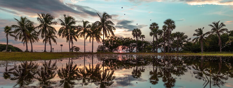
Explore the Florida Keys in Under 24 Hours
Ready to experience the beauty of the Florida Keys in under 24 hours? Here’s a road trip you won’t forget! Start your day off with a sunrise over the Atlantic Ocean and end it with a sunset on the Gulf of Mexico. Go snorkeling, kayaking, or fishing in crystal-clear waters. Get cozy in the tiny towns that dot the keys, from Key Largo to Key West. Immerse yourself in the unique culture and try some local seafood delicacies.
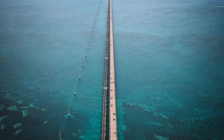
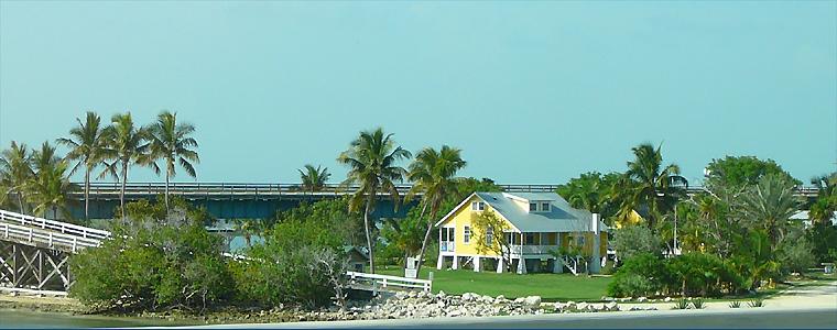
Take a scenic drive down the Overseas Highway and admire the breathtaking views of the Seven Mile Bridge, lighthouses, and mangroves. From historical sites to natural wonders, there’s something for everyone to see and do in the Florida Keys. So pack your bags and hit the road – adventure awaits!
Start: John Pennekamp Coral Reef State Park
In addition to the glass-bottom boat tours, the park offers a variety of other activities, including snorkeling, diving, kayaking, and fishing. The knowledgeable staff at John Pennekamp Coral Reef State Park are always ready to assist those new to these activities. Snorkelers can explore many secluded coves and hidden reefs, while experienced divers will find deep-water coral gardens teeming with life. Kayaks and boats are also available for rent for visitors who want to take in the sights from above the surface. Lastly, anglers will find plenty of opportunities with species like grouper, snapper, and amberjack, all regularly found in the waters surrounding Key Largo. With its rich underwater ecosystem, no matter what activity you choose, John Pennekamp Coral Reef State Park is sure to be a delightful experience.

John Pennekamp Coral Reef State Park offers many activities for the whole family. From the thrilling glass-bottom boat tours to snorkeling, diving, kayaking, and fishing, there is something to suit everyone’s tastes. Whether you’re an experienced diver or a first-time snorkeler, the knowledgeable staff is ready to assist you in discovering this unique underwater paradise. Relax in shallow coves and explore hidden reefs, or take in the views from above with a kayak or boat rental. For anglers, there are plenty of opportunities for catching grouper, snapper, and amberjack in the waters around Key Largo. With its breathtaking beauty and vibrant ecosystem, John Pennekamp Coral Reef State Park will surely be an unforgettable experience for all.
Stop 1: Florida Keys History of Diving Museum
82990 Overseas Hwy, Islamorada, FL 33036
Directions from John Pennekamp Coral Reef State Park: Follow Mile Marker signs to Mile Marker 83
- Distance from Previous Site: 19.5 miles / 31.2 km
- Travel Time from Previous Site: 26 minutes
- Suggested Time at This Site: 1 hour
At the Florida Keys History of Diving Museum, the international story of 3,000 years of underwater exploration is told, and the unique role that the Florida Keys played is celebrated. Stroll through numerous exhibits with hundreds of rare dive helmets, armored dive suits, old navy gear, ancient diving machines, an atmosphere decompression chamber, photographs, and oral history.
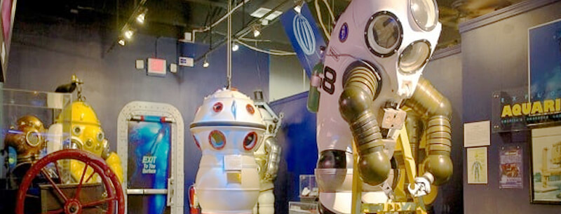
Visitors can immerse themselves in over 3,000 years of underwater exploration, discovering the Florida Keys’ special role in this history. A vast array of rare artifacts, from intricate dive helmets to armored dive suits and old diving machines, are on exhibit for visitors to explore. These artifacts, paired with photographs and oral histories, create an atmosphere of intrigue and amazement. Furthermore, the museum also has a remarkable atmosphere decompression chamber that visitors can tour, offering a unique view into deep sea diving. With its fascinating artifacts and interactive exhibits, the Florida Keys History of Diving Museum is the perfect place to learn more about the incredible history of diving.
Stop 2: Robbie’s Marina
77522 Overseas Hwy, Islamorada, FL 33036
Directions from History of Diving Museum: Follow Mile Marker signs to Mile Marker 77.5.
- Distance from Previous Site: 5.5 miles / 8.8 km
- Travel Time from Previous Site: 8 minutes
- Suggested Time at This Site: 30 minutes
Robbie’s Marina, with a beautiful view of the bay, captures the Old Keys lifestyle. It’s always feeding time at the dock, where you can get a bucket of bait fish and hand-feed dozens of tarpon, some up to six feet long. Boats, kayaks, and tours are all available to see dolphins, sea turtles, eagle rays, sharks, osprey, and egrets. Fishing charters are ready and waiting, whether you want deep-sea or flats fishing in the “backcountry.”
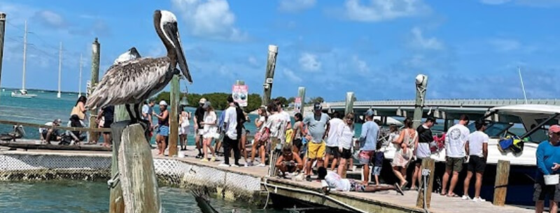
Robbie’s Marina is where time stands still, allowing visitors to experience the charm and beauty of the Old Keys lifestyle. Whether you’re looking for an adventure out on the bay or a leisurely day of fishing, the possibilities are endless. You can feed dozens of tarpon at the dock with a bucket of bait fish, enjoying their playful antics as they compete for your attention. When you’re ready to explore further, boats, kayaks, and tours are available to take in the area’s wildlife – keep an eye out for dolphins, sea turtles, eagle rays, sharks, osprey, and egrets. For the more adventurous angler, there are fishing charters to choose from – deep sea or backcountry flats fishing for whatever catches your fancy. Robbie’s Marina has something for everyone to make your visit to the Keys unforgettable.
Stop 3: Anne’s Beach
Lower Matecumbe Key, Islamorada, Florida
Directions from Robbie’s Marina: Follow signs to Mile Marker 73.5.
- Distance from Previous Site: 4 miles / 6.4 km
- Travel Time from Previous Site: 6 minutes
- Suggested Time at This Site: 1 hour 30 minutes
At Anne’s Beach, stretch out on the sand and slip your toes into the turquoise water to swim in the calm, clear Atlantic Ocean while kiteboarders take advantage of the tropical sea breeze. See fishermen, stone crabbers, and lobster farmers capture their bounties. Linger along a private boardwalk and picnic at shaded tables among the native mangroves.
Visitors can take a dip in the warm Atlantic and watch kiteboarders perform daring tricks, a beautiful sight set against the backdrop of the tropical horizon. Nature lovers can explore the secluded boardwalk, home to native mangroves, while fishermen, stone crabbers, and lobster farmers work together to bring in their daily catch. Visitors can sit back and enjoy a picnic at one of the many shaded tables scattered throughout the beach. With its clear waters, lush wildlife, and activities for all ages, Anne’s Beach is the perfect escape from everyday life.
Stop 4: Dolphin Research Center
Directions from Anne’s Beach: Follow signs to Mile Marker 59, bayside
- Distance from Previous Site: 14.5 miles / 23.2 km
- Travel Time from Previous Site: 20 minutes
- Suggested Time at This Site: 2 hours
The Dolphin Research Center was founded in 1946 as a marine research and educational facility and is home to a family of Atlantic bottlenose dolphins and California sea lions. Enjoy educational tours and shows in their bayside theater. Enter the exciting world of the dolphins by participating in a playful, structured, interactive program. Call ahead to reserve a deep or shallow-water dolphin encounter.

The Dolphin Research Center is a special place where visitors can immerse themselves in the incredible world of dolphins and sea lions. Founded in 1946, the center has been dedicated to marine research and education. From educational tours to bayside theater shows, the facility offers plenty of opportunities to learn about and interact with these majestic creatures. F
Stop 5: Pigeon Key
Directions from Dolphin Research Center: Follow Mile Marker signs to Mile Marker 47, bayside.
- Distance from Previous Site: 12 miles / 19.2 km
- Travel Time from Previous Site: 20 minutes
- Suggested Time at This Site: 2 hours
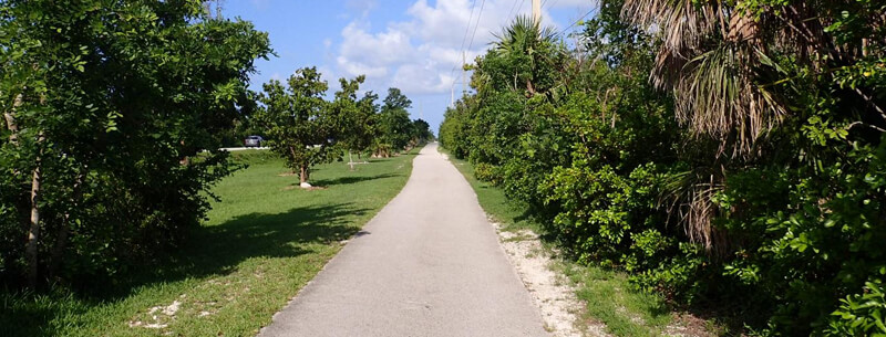
Walk or bike to Pigeon Key on the historic Overseas Highway Bridge to see the 5-acre island that served as a base camp for the hundreds of men who built the Key West Extension of the Railroad. The 100-year-old tin-roofed, wood clapboard buildings are now a museum. Visitors find many photo opportunities on the historic bridge and tropical island. Snorkeling and picnicking are also a pleasure at this unique location.
Take a journey back in time and explore the iconic Overseas Highway Bridge as you walk or bike to Pigeon Key. As you approach this 5-acre slice of paradise, you can almost hear the clanking of hammers from the hundreds of men who built the Key West Extension of the Railroad over a century ago. Upon arrival, marvel at the wooden clapboard buildings with distinctive tin roofs, now a museum waiting to share its secrets. Along the bridge, numerous photo ops capture a moment in time and provide a unique perspective of the tropical island. After you snap your shots, take time to snorkel in the crystal-clear waters and enjoy a picnic lunch on the beach. Whether taking a stroll down memory lane or simply enjoying nature, Pigeon Key offers something magical to be discovered.
Stop 6: Bahia Honda State Park
36850 Overseas Highway, Big Pine Key, FL 33043
Directions from Pigeon Key: Follow Mile Marker signs to Mile Marker 37, Oceanside
- Distance from Previous Site: 10 miles / 16.0 km
- Travel Time from Previous Site: 12 minutes
- Suggested Time at This Site: 1 hour 30 minutes
Bahia Honda State Park is home to one of the top “Top Ten Beaches in the United States” and offers camping, fishing, diving, snorkeling, hiking and kayaking. Walk onto Flagler’s Historic Railroad trestle and enjoy the views of the Atlantic Ocean and Gulf of Mexico. Relax on the beach, take a swim in the calm, clear water, explore the nature trail, or picnic in one of the pavilions. For a few hours or a few days, the park has year around appeal.

Bahia Honda State Park is a paradise for any outdoor enthusiast. From relaxing on the beach to exploring the nature trail and kayaking, there’s something for everyone. The park boasts one of the top “Top Ten Beaches in the United States” and offers an array of activities such as camping, fishing, and snorkeling. For an added thrill, visitors can walk onto Flagler’s Historic Railroad trestle and enjoy the stunning views of the Atlantic Ocean and the Gulf of Mexico. Whether you’re looking for a day trip or a week-long holiday, Bahia Honda State Park has a year-round appeal. Enjoy a swim in the crystal clear waters, picnic at one of the pavilions, and make memories to last a lifetime.
Stop 7: Southernmost Point
Directions from Bahia Honda State Park: Follow Mile Marker signs to Mile Marker 0. Turn left from Truman Avenue (FKSH) onto Whitehead Street and drive seven blocks to its end at South Street and the Southernmost Point marker.
- Distance from Previous Site: 37.6 miles / 60.2 km
- Travel Time from Previous Site: 1 hour
- Suggested Time at This Site: 15 minutes
The Southernmost Point marker is one of the most photographed landmarks in the United States. The giant yellow, red, and black striped, buoy-shaped monument marks the Southernmost Point in the Continental United States, noting that Cuba is only 90 miles away. The site commemorates the brave Cubans who drowned trying to reach the land of their dreams, “The Leader in Democracy.”
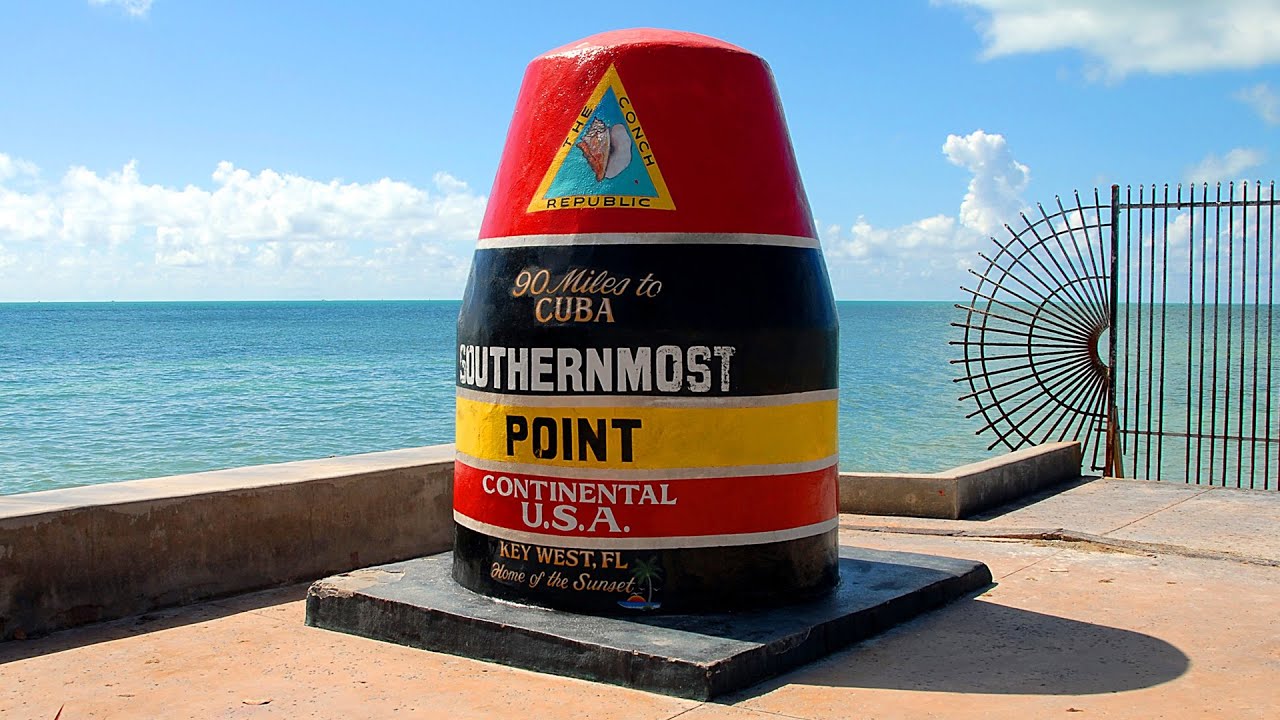
Located at the southernmost tip of the United States, the Southernmost Point marker is a reminder of the power of hope and freedom. Its iconic yellow, red, and black stripes evoke a sense of courage and strength, while its buoy shape conveys an image of a safe haven. This monument marks the furthest point south on the continental US, a mere 90 miles from Cuba—a country whose citizens have risked their lives to seek a better future in America. Visiting this monument pays tribute to those brave souls whose dreams of freedom have inspired countless others. It is also a reminder that America must continue to strive for its promise of liberty, justice, and democracy to all. Despite the dangers they faced, these determined immigrants held fast to their hopes of a better life, and this historic site reminds us of their courage and resilience.
Stop 8: Hemingway Home and Museum
Directions from Southernmost Point: Located .25 miles south of Mile Marker 0. Return on Whitehead Street driving eight blocks to the corner of Olivia Street.
- Distance from Previous Site: 0.35 miles / 0.6 km
- Travel Time from Previous Site: 2 minutes
- Suggested Time at This Site: 1 hour
Ernest Hemingway Home and Museum is where one of America’s most honored authors called home for more than 10 years and visited frequently in his later life. He found solace and great physical challenges fishing the turquoise waters surrounding Key West. Tour the rooms and gardens that inspired the most prolific period of the Nobel Prize winner’s career, and meet the living descendants of his legendary six-toed cats.
Ernest Hemingway’s home and museum in Key West, Florida, provides a captivating window into the life of one of America’s most beloved authors. Here, visitors can immerse themselves in the culture and beauty of the island that inspired Hemingway’s most productive years as a writer. Tourists can explore the rooms and gardens where he wrote some of his most acclaimed works and get up close with the descendants of his legendary six-toed cats. Walking around these hallowed grounds allows visitors to appreciate the solace Hemingway found in the turquoise waters of the Gulf of Mexico and the physical challenges of fishing in the area. With its history and picturesque views, Ernest Hemingway Home and Museum is an unforgettable experience for any literary enthusiast.
Stop 9: Key West Lighthouse and Keepers’ Quarters Museum
Directions from Hemingway Home and Museum: Located .25 miles south of Mile Marker zero. Walk across Whitehead Street from previous stop.
Travel Time from Previous Site: 1 minute
Suggested Time at This Site: 1 hour
Key West Lighthouse and Keepers’ Quarters Museum is the 15th-oldest surviving lighthouse in the United States and was brought to its present height of 86 feet in 1894. Visitors can climb 88 steps to the balcony for a spectacular view of the island, the Atlantic Ocean, and Gulf of Mexico, and tour the Keepers’ Quarters that host a lighthouse Fresnel lens large enough to walk into, historical instruments, maps, and photos depicting its rich maritime history.
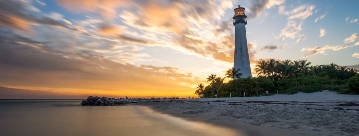
Key West Lighthouse and Keepers’ Quarters Museum visitors can experience a unique window into maritime history. Ascend the 86-foot tower and be rewarded with stunning vistas of the island, Atlantic Ocean, and Gulf of Mexico. Inside the Keepers’ Quarters, explore artifacts that tell the story of a bygone era, such as a massive Fresnel lens you can literally step inside. Immerse yourself in the collection of ancient instruments, maps, and photographs that bring you back to the 1800s. With its fascinating history, spectacular views, and one-of-a-kind artifacts, this museum will leave a lasting impression on all who visit.
Stop 10: Fort Zachary Taylor State Park
Directions from Key West Lighthouse: Located .6 miles from Mile Marker 0. Continue from previous stop on Whitehead Street, driving three blocks. Turn left on Southard Street and follow the signs to the park entrance.
- Distance from Previous Site: 0.25 miles / 0.4 km
- Travel Time from Previous Site: 5 minutes
- Suggested Time at This Site: 2 hours
Fort Zachary Taylor State Park is named for its Civil and Spanish-American War Fort. On a guided tour or on your own, bring a camera for the incredible view from the top of the Fort of the confluence of the Atlantic Ocean and the Gulf of Mexico. BBQ in the shade of trees or lay out on the sandy beach. Snorkel and see reef fish, coral, lobster, sponges, and stingrays in the calm, clear water.

Set in the heart of Key West, Florida, Fort Zachary Taylor State Park is a paradise of natural beauty and historical significance. Named after the Civil War and Spanish-American War hero Zachary Taylor, the park boasts spectacular views from the top of the fort, where the Atlantic Ocean and Gulf of Mexico meet. Visitors can explore the park’s lush gardens, shady trees, and sandy beach with a camera or snorkeling in the tranquil, aquamarine waters. Visitors can find abundant marine life, such as coral, lobster, sponges, and stingrays. When hunger strikes, guests can set up for a picnic under the trees or fire up the BBQ for a delicious meal. Whether seeking a relaxing day by the beach or adventure amongst nature, this park offers a rich experience like no other.
Stop 11: Schooner Western Union
Directions from Fort Zachary Taylor State Park: From previous stop return on Southard Street to Whitehead Street and turn left. Drive three blocks to Caroline Street and turn right. Drive four blocks to William Street and turn left (see public parking lot to your right and the Schooner Western Union straight ahead). Located 0.75 miles from mile marker 0.
- Distance from Previous Site: 1.25 miles / 2.0 km
- Travel Time from Previous Site: 8 minutes
- Suggested Time at This Site: 2 hours
Take a sunset sail on one of America’s oldest working wooden schooners, built in Key West in 1939. Be part of the show coasting past the Mallory Square Sunset Celebration into the tranquil waters of the Atlantic while the fiery sun disappears from view.
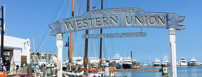
Sail away into the sunset aboard the historic schooner, the grandest vessel of Key West’s waters. Feel the breeze fill the sails and take you away as you coast past the colorful Mallory Square Sunset Celebration. Let your eyes soak in the vibrant hues that adorn the sky, their beauty only growing more intense as they slowly give way to shades of navy blue and a deep, starry night. Listen to the gentle lapping of the waves and the creaks of the wooden ship beneath your feet, and let the serenity of the moment envelop you. On this peaceful voyage, feel your worries drift away with the sun until you reach the horizon’s edge, with nothing but the stars to guide you.
End: Florida Keys Overseas Heritage Trail
Travel Time from Previous Site: 5 minutes
The journey on the Florida Keys Scenic Highway, parallel to the Overseas Heritage Trail, is an incomparable destination itself. Seeing the Atlantic Ocean and the Gulf of Mexico out either window is an unparalleled experience, their shallow shelf of clear water reflecting bright turquoise, emerald, and aquamarine. The reef keeps the near-shore waters calm as evidenced by boats of all kinds on the horizon. The tempo slows, and relaxation sinks in as palm trees sway in the tropical breeze. And the bridge crossings bring you the sense of being out on the island chain in a way that is only traversing the Keys by land can.
The Florida Keys Scenic Highway is a journey unlike any other. As you drive parallel to the Overseas Heritage Trail, you can feel the region’s tranquility enveloping you. On either side, bright turquoise, emerald, and aquamarine water from the shallow shelf of the Atlantic Ocean and Gulf of Mexico sparkles in the sun. Boats dot the horizon, and the peacefulness of the reef-protected waters is palpable. The swaying palm trees in the tropical breeze add to the atmosphere of serenity while navigating the bridges, bringing an incomparable sense of being in the island chain. With such breathtaking beauty, the Florida Keys Scenic Highway is an unforgettable experience.
Summary
- Total Distance Traveled: 104.95 miles / 167.9 km
- Total Travel Time: 2 hours 53 minutes
- Total Stopping Time: 14 hours 45 minutes