Utah National Parks Guide
The state of Utah derives its name from Ute Indians and carries the meaning of “people of the mountains“. However, Utah not only has some stunning snowcapped mountain ranges but also rugged deserts and river valleys. Colorado and Green are the two major rivers that flow through the state. Its geographical diversity is one of the reasons why the state is a preferred tourist destination.
Its two National Recreation Areas and six National Forests present tourists with ample encounters with nature and also endless recreational prospects. For skiing enthusiasts, Utah is the place to be. Referred to as the “greatest snow on earth“, Utah has the perfect skiing conditions and its acclaimed Ski Resorts enhance the thrill manifold. Sundance in Provo Canyon, Alta, and Solitude in Salt Lake City and Deer Valley Resort in Park City are some of the internationally acclaimed skiing destinations. Biking, fishing, hiking, boating and ice skating opportunities are also aplenty.
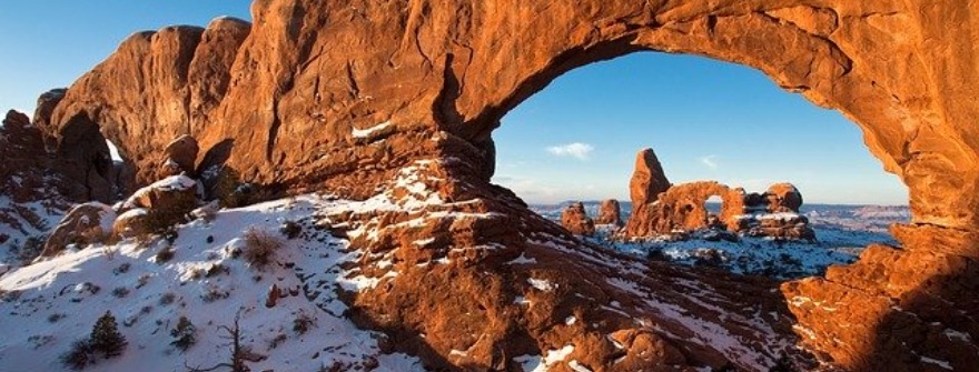
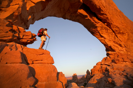
Arches National Park, Utah
Arches National Park, Utah is a red, arid desert. It is one of the least terrestrial places on this planet. Massive fins of red and golden sandstone stand to attention out of this bare desert, and over 1800 natural arches have been cut into the rocks by centuries of erosive weathering. Watching under a full moon, you could be excused for imagining that the landscape has a life of its own.
To do Arches justice, you should plan to spend a full day here at least. The visitor center sells brochures explaining the simple process by which the arches are formed and points out some of the more photogenic examples. The first possible stop is Park Avenue, an easy trail. If you stay on the road, the La Sal Mountains Viewpoint provides a grand-stand look at the distant peaks rising over 12,000 ft above the surrounding desert.
From Balanced Rock, a 50 ft boulder atop a slender pedestal, you can enter the Windows section. From here, a half-mile trail leads through a dense concentration of massive arches, some over 100 ft high and 150 ft across. A second trail, fifty yards beyond, leads to Double Arch, a par of arches that together support another arch overhead. There are a few trails into remote areas and they are extremely rewarding.
Permits for backcountry camping, allowed anywhere that’s a mile from the road and half a mile from any trail, are issued at the visitor center. Arches’ only campground is a first-come, first-served site, and tends to be occupied by early morning in season.
Bryce Canyon National Park, Utah
The surface of the Earth can hold few weirder-looking spots than Bryce Canyon. The Bryce Canyon is in fact not a canyon at all. Along a twenty-mile shelf on the eastern edge of the thickly forested Paunsaugunt Plateau, 8000ft above sea level, successive strata of dazzling colored rock have slipped and washed away to leave many contorted stone shapes.
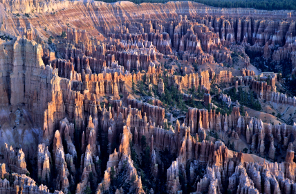
Many of the formations in Bryce Canyon have been eroded out of the muddy sandstone by a combination of icy winters and summer rainstorms. The racks of top-heavy pinnacles known as ‘hoodoos’ were formed when the harder upper layers of rock stayed firm as the lower levels were worn away beneath them. Thor’s Hammer, visible from Sunset Point, is the most alarmingly precarious. The whole place is at its most inspiring in the winter when the figures stand out from a blanket of snow.
Of the succession of scenic overlooks into Bryce Amphitheater, at the heart of the park, the two most popular are on either side of Bryce Canyon Lodge; the more northerly, Sunrise Point, is slightly less crowded than Sunset Point. A network of hiking trails drops abruptly from the rim down into the amphitheater. One good three-mile trek switchbacks steeply from Sunset Point through the 200 ft canyons of Wall Street, where a pair of 800-year old firs stretch to reach daylight.
The best view at both sunrise and sunset (which is the best time for taking pictures) is from Bryce Point, at the southern end of the amphitheater. From here, you can look down not only at the Bryce Canyon formations but also take in the grand sweep of the whole region, east to the Henry Mountains and north to the Escalante Range.
Canyonlands National Park, Utah
Canyonlands National Park is the largest and most magnificent of Utah’s national parks. Canyonlands is a bewildering tangle of canyons, plateaus, fissures, faults, pierced by arches and caverns, and penetrated by only a handful of dead-end roads. The 527 square miles of the park is just the core of a much larger wilderness that stretches to the horizon in every direction.
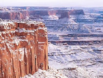
Canyonlands National Park focuses on the Y-shaped confluence of the Green and Colorado rivers, buried deep in the desert forty miles southwest of Moab. With no road down to the rivers, the park, therefore, splits into three different sections. The Needles, east of Colorado, is a red-rock wonderland of sandstone pinnacles and hidden meadows that’s a favorite with hikers. The Maze, west of the rivers, is a labyrinth of tortuous canyons.
The Island in the Sky offers astonishing views across the whole park and beyond, with several overlooks that can easily be toured by car. Getting from any of these sections to the others involves a drive of at least a hundred miles, so the Canyonlands is not a place that lends itself to a short visit. With no lodging and little camping inside the park, it takes a full day to even have a cursory look at a single segment.
A small part of Canyonlands is separate from the main park – the Horseshoe Canyon Unit, which covers a section of a canyon of Barrier Creek, and has many Indian figures painted on rock walls 2000 years ago.
Capitol Reef National Park, Utah
The Capitol Reef National Park contains towering white and red rock walls, along with deep river canyons. The outstanding feature of this park is a multi-layered, 100 ft-high reef-like wall of uplifted sedimentary rock, a section of which resembles the grand dome of the US Capitol. The sharply defined sedimentary layers on display here trace over two hundred million years of geological activity.
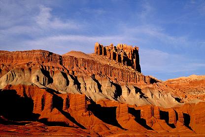
Capitol Reef National Park offers an assortment of activities to visitors. Beneath the very prominent Castle, the visitor center has explanatory exhibits and an irresistible campground, set amid the cherry, apple and peach orchards of the abandoned Mormon community. One of Capitol Reef’s best hikes is along the gravelly riverbed through Grand Wash – a beautiful and cool canyon, where, it is said, Butch Cassidy used to hide out.
Stretching for over a hundred miles north to south, the seemingly impenetrable barrier of Waterpocket Fold is sliced through in a number of places by deeply incised river canyons-some only twenty feet wide, but hundreds of feet deep-often accessible only by foot. Few other paved routes run through the park, so to reach the spectacular backcountry canyons you may have to put up with many miles of dusty roads.
Visitors to the park also engage in activities like guided walks and evening programs, fishing on the Fremont River above the park, and rock climbing.
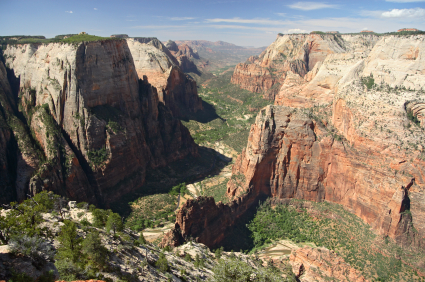
Zion National Park, Utah
With its soaring cliffs and cascading waterfalls, Zion National Park is the most beautiful of Utah’s national parks. Its centerpiece, Zion Canyon, is a huge oasis that resembles California’s Yosemite Canyon. It’s a spectacular gorge, squeezed between mighty walls of rock and echoing to the sound of running water. However, the approach roads to the park get clogged with traffic in the summer and its limited facilities get crammed.
Most visitors see Zion Canyon as a quick half-day detour off the interstate, but Zion deserves much more of your time than that. Even the shortest trails within the canyon can help you escape the crowds. Less ambitious walkers can wander up to the Weeping Rock, a half-hour trip from the road to a gorgeous spring-fed garden. A more exciting route cuts through Hidden Canyon, whose mouth turns into a waterfall after the rains. Another fairly flat trail leads up to Emerald Pools, a series of three clear water pools.
The best half-day hike climbs up to Angel’s Landing, a narrow ledge of sandstone protruding 1750 ft above the canyon floor. Starting on the same route as Emerald Pools, the Angel’s Landing Trail turns sharply up through the coolness of Refrigerator Canyon before emerging out; near the end, you have to cross a five-foot neck of rock with sheer drops on either side.
The high plateau above and to the east of Zion Canyon, reached by continuing on the Scenic Drive turnoff, is a complete contrast to the Virgin River gorge. Its most dramatic sight is the blind Great Arch, best seen from the turn before the mile-long tunnel. Beyond this spot, the Canyon Overlook nature trail begins, where hikers can take a look at the flora and fauna of the park. Summer is by far the busiest season in the park, even though temperatures soar in excess of 100 F.