Colorado National Parks Guide
Divided into 64 counties, the rich history of Colorado has offered 20 locations under the National Historic Landmarks list, with Bent’s Old Fort, The Central City/Black Hawk Historic District and the Durango and Silverton Narrow Gauge Railroad (D&SNG) being popular with tourists. Though predominantly the climate is cool, the mountain ranges, valleys, broad basins and plateaus in the region ensure that Colorado has significant climatic variation from one part of the state to another.
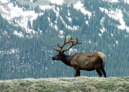
Tourists are greatly attracted to Colorado for its awesome scenic locations and state-of-art skiing resorts. Also, with an extensive landscape managed by National Forest lands, Colorado has four beautiful National Parks within its boundaries. The Rocky Mountain National Park is the prime attraction with Longs Peak, Bears Lake and Wild Basin offering some great recreational activities. The Mesa Verde National Park, Colorado National monument and the world-renowned and Dinosaur National Monuments are the other hot spots not to be missed in Colorado.
For everyone who wishes to get away from the crowds, Colorado’s getaways are a perfect choice. For everyone who wants to get the best of modern living, dining and shopping Colorado cities have world-class offerings.
Black Canyon of the Gunnison National Park, Colorado
The Black Canyon of the Gunnison National Park lies in western Colorado near the town of Montrose. The Black Canyon of the Gunnison’s spectacular landscape combines narrow openings, sheer walls, and startling depths. The Black Canyon of the Gunnison was recently upgraded to national park status.
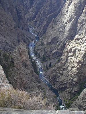
This Park has one of the steepest and most rugged of canyons, which is formed by the Gunnison River as it flows through the western edge of the Rocky Mountains. The canyon walls are covered with volcanic ash, and the gorge reaches depths of over 2,000 feet. Sunlight illuminates the walls only for a short while, hence the name ‘Black Canyon’. It is unsettling, almost frightening to stand at the edge of one of the canyon overlooks.
Backcountry camping requires a permit. Whenever you’re headed for anywhere at all isolated, be sure to inform a ranger of your plans, and ask about the weather and specific local tips. Backpackers should not drink from rivers and streams. Hiking at lower elevations should prevent a few problems, though the swarms of mosquitoes that you may encounter near water can be a serious headache.
The East Portal Road runs close to the river upstream to the East Portal Dam, which marks the boundary between the national park and the Curecanti National Recreation Area. However, all the canyon overlooks are found along the main entrance road. The road passes about 12 viewpoints, some of which require a short walk to see the canyon.
South Rim Road
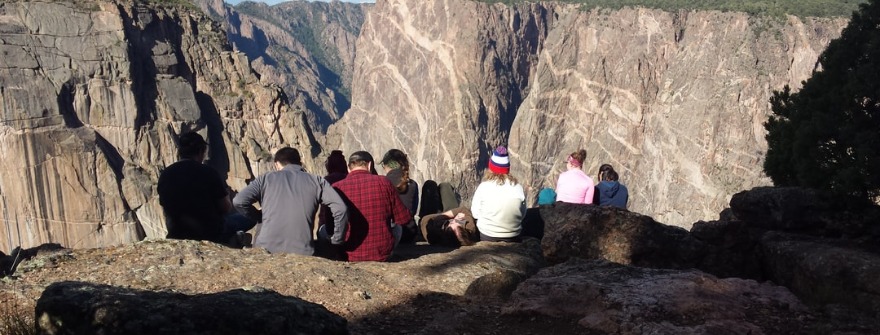
South Rim Road is a 13 mile (20.9 km) road that trails the condescending south rim of the Black Canyon of the Gunnison National Monument. Black Canyon is a huge, deep, precipitous gorge lacerated out of the ancient bedrock by the spectacular Gunnison River. The South Rim Road offers not only rare opportunities for nature study but also a wealth of breathtaking views, geologic lessons, and recreational activities. Great views of the Canyon are offered by as many as 12 overlooks situated along the Road. Most of these viewpoints can be accessed by walking a short trail.
The towering cliffs in the area provide exciting opportunities to the valiant rock climbers. Other tourist activities include camping, picnicking, hiking, photography, and wildlife viewing. A wide variety of birds and animals like raptors, swallows, mule deer, towhees, porcupines, and coyotes can also be spotted along the forested canyon rim. The South Rim also offers a number of short, easy trails that are good for exploring this area on foot. These include the Rim Rock Trail, the Oak Flat Trail, the Warner Point Nature Trail, and the Uplands Trail. The longer, strenuous hikes are offered only to the experienced hikers.
The major tourist attractions along the South Rim Road include the Black Canyon, Pulpit Rock Overlook, Tomichi Point, East Portal, Painted Wall View, Chasm View, High Point, and the Visitor Center. The Pulpit Rock overlook provides excellent views of a maze of towers, stone pillars, vertical fins, spires, and turrets protruding from the canyon walls. Besides, one can also view the sturdy Douglas firs and the Rocky Mountain white oaks, which have taken root on the little plateaus along the cliff. In order to enjoy the scenic Road to the fullest, one should allow at least 2-3 hours driving the 7 miles west from the park entrance to the end of South Rim Road.
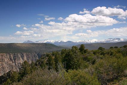
The Painted Wall Overlook, on the other hand, offers a spectacular vista of the highest rock wall in Colorado. This natural masterwork rises to about 1,800 ft (548.6 m) from the river. It flaunts pink pegmatite veins running through gray-black rock, giving it an appearance of a slab of marble tinted with stunning emerald green algae. High Point is the summit of the South Rim and offers panoramic views of the San Juan Mountains to the south, the Grand Mesa to the north, the Black Canyon widening beyond the park’s western boundary, and the West Elk Mountains to the Northeast. The South Rim Road
Great Sand Dunes National Park and Preserve, Colorado
Fifty square miles of silky shifting sands huddled against the Sangre de Cristo Mountains, the Great Sand Dunes National Park is around 170 miles southeast of Colorado Springs. Dunes have arisen in this surprising location thanks to millions of years of westerly winds blowing fine glacial sands from the San Juan mountains east to be trapped beside the Sangre de Cristos.
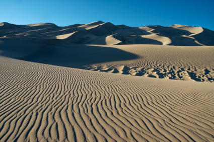
Looking for a way through the mountains, the prevailing winds were channeled towards the lower part of the range – near the Music, Medano and Mosca passes – where winds have been buffeted against the mountains, dropping their load at the base and forming the dunes. Winds blow here every day, so whilst footprints are not left for long, the dampness of the sand a foot below the surface means that the general shape of the dunes has remained unchanged for centuries.
An eerie, yet beautiful place, the dunes harbor a number of small creatures, including the giant sand-treader camel cricket and the small kangaroo rat. Most visitors go little further than Medano Creek, but the climb up the dunes themselves, though incredibly tiring, is not to be missed. A walk along sandy trails and a night spent out at one of the backcountry campsites are also worthwhile.
The visitor center is three miles beyond the park entrance. Behind the center, there is the Mosca picnic area – the main gateway for exploring the dunes. The most unforgettable way to stay at the dunes is to pitch on the dune mass itself..
Mesa Verde National Park, Colorado
Mesa Verde is the only American National Park that is devoted exclusively to archeological remains. It is set high up in the plateaus of Southwest Colorado, halfway between Cortez and Mancos. It’s an astonishing place, so far off the beaten track that its extensive Ancestral Puebloan ruins were not explored until 1888.
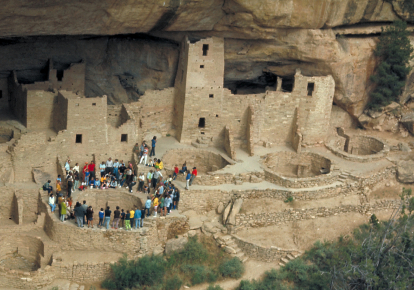
Read more in our dedicated Guide to Mesa Verde National Park
Rocky Mountain National Park, Colorado
The snow-mantled peaks of Rocky Mountain National Park offer many ways to experience nature in its entire splendor. The park preserves one small section of the mighty range, measuring roughly twenty-five by fifteen miles. A tenth of the size of Yellowstone, the park attracts the same number of visitors, and with the bulk of those coming in summer, the one road through the mountains can get incredibly congested.
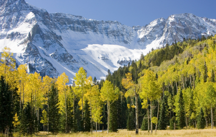
In spite of the problem of overcrowding, the park is undeniably beautiful, crossing the Continental Divide at elevations often well in excess of ten thousand feet. A third of the park is above the tree line, and large areas of snow never melt; the name of the Never Summer Mountains speaks volumes about the long, empty expanses of arctic-style tundra. Lower down, among the rich forests, are patches of lush greenery; if you are lucky, you might stumble upon a mountain meadow full of blooming flowers.
The park has often been compared with the European Alps. This is helped by the heavy-handed Swiss and Bavarian themes of the region’s hotels and restaurants. Approaching the park from the east, you barely penetrate the foothills of the Rockies before you arrive at the gateway town of Estes Park. The park headquarters and visitor center are located here.
To reach the western entrance, a small detour beyond the junction takes you to Georgetown, the starting point of the Georgetown Loop Railroad. On this line, you can see a 1920s steam train running a tortuous six-mile round-trip.
Trail Ridge Road
If you’re driving through Kansas or Nebraska, a scenic drive means that the view out the window will be slightly less repetitive than the one for the previous hundred miles. In Colorado, it’s a different story. Scenic drives in this state are the prettiest in the nation. Pretty enough to make you steer right off the road while you’re busy gawping. And you can’t help but gasp—literally–because the more stunning the view, the greater the drop-off. Only sissies need guardrails and hairpin bends at dizzying heights are nothing when you’ve scaled all the Fourteeners in the state. We had no idea what we were getting into when we decided to drive from Estes Park to Lake Granby, through Rocky Mountain National Park. Read more about Trail Ridge Rd >